Piri Reis Maps
The Newton Center for British-American Studies here at SCAD is an amazing place. It has been here for a while but I have only recently gone in. I loved it. They had many exhibits going, three of which were: 1) William Hogarth political etchings 2) American masterwork frames from 1890 - 1940 and 3) "Mapping the Past: A Selection of Antique Cartography from the Newton Collection"
I love maps. They ride the perfect balance between nature and science, abstraction and precision. Beyond they're usefulness they are beautiful, especially the old maps. I'm talking 15th, 16th century, when it was just as much an art as a science. The cartographers would embellish a map with fancies of design and etchings of now cryptic symbolism. The type of maps that really gets my blood flowing, however, are the ones which are wrong. Cartographers would leave off whole unknown geographies, or even better make them up. I want reprints of these for my walls. Where can I get quality reprints for cheap?

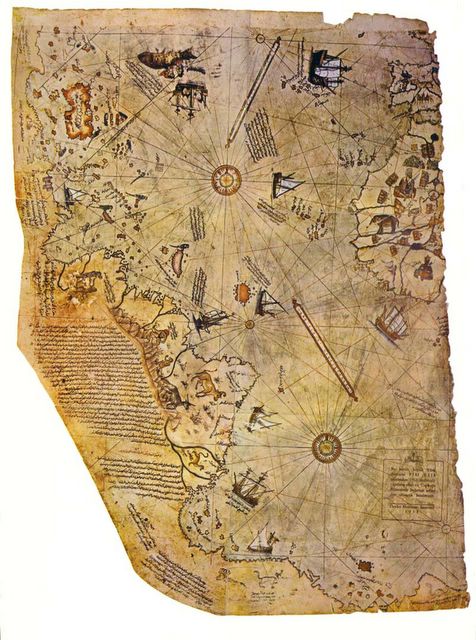
Anyway, this isnt about maps that are wrong, but about a particular ancient map that is amazingly right. Piri Reis was a Turkish Admiral Guy in the fifteen hundreds who drew a map of much of the Atlantic coast lines to an accuracy that is uncanny. The Piri Reis map shows the western coast of Africa, the eastern coast of South America, and the northern coast of Antarctica. The northern coastline of Antarctica is perfectly detailed. The most puzzling thing, however is not so much how Piri Reis managed to draw such an accurate map of the Antarctic region 300 years before it was discovered, but that the map shows the coastline under the ice (currently a mile thick). Geological evidence shows that the latest date Queen Maud Land could have been charted in an ice-free state is 4000 BC. It took until 1949 for us to use seismic profiling to figure what Piri Reis knew in 1513 (21 years after Columbus found the West Indies). Piri Reis himself admitted that the map is not a pure original, but a combination of earlier maps. Where did this information come from? Due to the knowledge of spherical geography required, many people claim aliens, or ancient "gods" (same difference) provided the required insight. That's kind of conspiracy-theoryish, but is there a better explanation?
Here is a more detailed write up.
I love maps. They ride the perfect balance between nature and science, abstraction and precision. Beyond they're usefulness they are beautiful, especially the old maps. I'm talking 15th, 16th century, when it was just as much an art as a science. The cartographers would embellish a map with fancies of design and etchings of now cryptic symbolism. The type of maps that really gets my blood flowing, however, are the ones which are wrong. Cartographers would leave off whole unknown geographies, or even better make them up. I want reprints of these for my walls. Where can I get quality reprints for cheap?
Anyway, this isnt about maps that are wrong, but about a particular ancient map that is amazingly right. Piri Reis was a Turkish Admiral Guy in the fifteen hundreds who drew a map of much of the Atlantic coast lines to an accuracy that is uncanny. The Piri Reis map shows the western coast of Africa, the eastern coast of South America, and the northern coast of Antarctica. The northern coastline of Antarctica is perfectly detailed. The most puzzling thing, however is not so much how Piri Reis managed to draw such an accurate map of the Antarctic region 300 years before it was discovered, but that the map shows the coastline under the ice (currently a mile thick). Geological evidence shows that the latest date Queen Maud Land could have been charted in an ice-free state is 4000 BC. It took until 1949 for us to use seismic profiling to figure what Piri Reis knew in 1513 (21 years after Columbus found the West Indies). Piri Reis himself admitted that the map is not a pure original, but a combination of earlier maps. Where did this information come from? Due to the knowledge of spherical geography required, many people claim aliens, or ancient "gods" (same difference) provided the required insight. That's kind of conspiracy-theoryish, but is there a better explanation?
Here is a more detailed write up.
posted by Stephen "Steve" at 2/28/2005 09:11:00 PM
![]()
![]()


6 Comments:
Very cool stuff. Do you like Hogarth? I got a huge book of his engravings a couple years ago at a used bookstore, they're so amazing. I keep meaning to scan some and do something, or even frame some. A lot of them are even too disturbing to put on my walls though.
I saw an old map exhibit you would have gone ga-ga for. I went to the SD Maritime Museum last week, and they had an exhibit of old maps from the 1500s-1850, mostly Spanish and French maps of the New World. They were amazing in their detail. I assume most were prints but they were treated as if they were the real thing, kind of guarded behind special glass, so maybe they were old copies of originals.
This company, www.raremaps.com in San Diego, had lent about 20 to the exhibit, the rest were from another private collection. This is one of the ones they had:
http://www.raremaps.com/maps/big/9027.jpg
Almost all of the New World ones (even up to the early 1700s) show California and Baja as a huge island disconnected from the mainland.
Posted by Justin
Yeah, Justin, Hogarth is pretty amazing. I'm sure that book is great. He was so wonderful with overloading details, that I'm sure I would pour over that book for hours.
That map is great. Why don't they sell a cheaper repoduction of it, maybe poster style, for people like me w/o hundreds of thousands of dollars to throw away.
What you don't realize is that California really IS an island. Modern cartographers have got it all wrong.
Posted by Steve
Damn right we are a island. At least sometimes it feels that way looking at some of the other states.
You know Bilbo Baggins always had a thing for fine maps...
courtney
Posted by Anonymous
Here are some cool ones I copied from the book:
image1
image2 Look at the guy on the far left! haha.
Posted by Justin
I love maps, too. I love them so much that I'm majoring in Geography, even though it can be a useless degree . . . but I get to look at maps all day, and learn how to make them! I'm glad I'm not the only one. I've gotten many a strange look for telling people that.
Posted by Elizabeth
I was looking at the lampshade in the room I'm staying in the other night (aka The Fish Room), and I noticed the pattern is all old maps, and one of those maps has Cali as an island. Here is the pic I took of it. What's up with that?
Posted by cory